Send an enquiry SL

NaHrib: hikes, walks and mountain tours in Slovenia

Our own product: a web application where you pick a hike by filters, check conditions before you leave and find the trailhead, parking and hut on the map.

  • Own product
  • Web app (PWA)
  • Interactive map
  • SL, HR, EN, DE
  • Open data
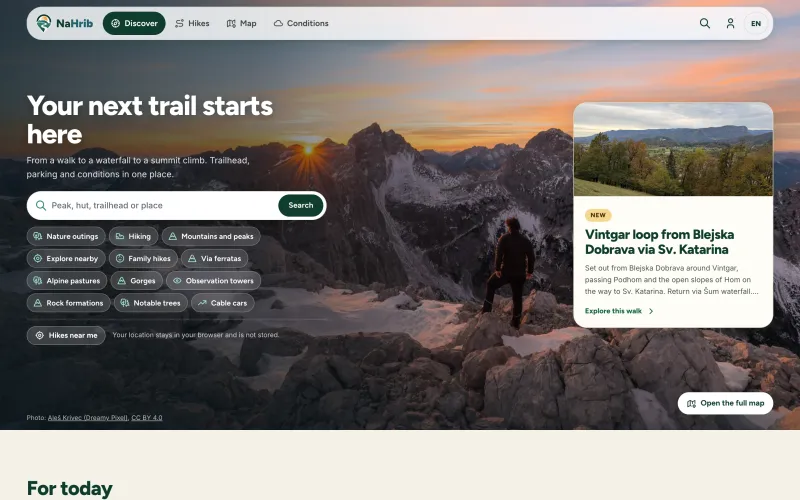
The NaHrib home page with the heading “Your next trail starts here”, hike search, categories and a suggested walk around Vintgar
Live website
nahrib.app/en
Launched
2026
Scope
359 hikes · Filters that fit the hiker · Conditions with source and time · Map · Long-distance trails · My hikes
Case study author
Tomaž Dolžan

Related service: Custom app development

Challenge

NaHrib is our own product. Anyone looking for a hike often has to open several sites before leaving: one for the route description, another for parking, a third for the hut and a fourth for conditions.

A family with children, a dog owner and a mountaineer are not looking for the same route. We wanted a search that first asks who you are going with and how much time you have.

Goal: One place where you choose a route by your own criteria and, before leaving, see the trailhead, parking, hut and conditions with their source.

Solution

Hikes are grouped by type: nature outings, hiking, mountains and peaks, family hikes, via ferratas, alpine pastures, gorges and other sights. The list can be filtered by difficulty, maximum hours of walking and ascent, by whether dogs are allowed and whether the route suits children, and by a hut on the route, parking at the trailhead and loop routes.

Conditions are always shown with their source and time: an official report, an ARSO forecast or a community report, which is marked as unverified. You know how old a piece of information is and where it comes from.

If you allow location access, you get nearby hikes within a radius of 10 to 100 km. The location is used only for that search, rounded to about one kilometre, and is not stored. In My hikes you keep a personal logbook, favourite tours and summit stamps; tours saved on the device stay available without an account.

What NaHrib includes

  • 359 hikes

    That is how many were listed on 10 November 2026, from family walks to via ferratas.

  • Filters that fit the hiker

    Difficulty, hours of walking, ascent, dogs, children, a hut on the route, parking and loop routes.

  • Conditions with source and time

    An official report, an ARSO forecast or a community report, always labelled.

  • Map

    Trailheads, huts and routes on the map, with a difficulty legend on the SAC scale.

  • Long-distance trails

    International and national trails by stage, for example the Juliana Trail with 16 stages.

  • My hikes

    A personal logbook, favourite tours and summit stamps, private until the user chooses otherwise.

  • Four languages

    Slovenian, Croatian, English and German.

How NaHrib is designed

The application combines public data sources and credits them where they are shown. The map credits OpenStreetMap, Protomaps, GURS, ARSO, the cultural heritage register, Natura 2000 and OPSI for car parks.

  • Our own map tile source

    The map is served from our own tile source, not from the public OpenStreetMap servers.

  • Difficulty stated plainly

    The difficulty rating uses the SAC scale from OpenStreetMap data and is explicitly marked as not an official rating of the Alpine Association of Slovenia.

  • Location stays with the user

    For nearby search the location is rounded to about one kilometre and is not stored.

Note: We do not publish user or visit numbers, because we cannot document them verifiably in this case study.

Result

NaHrib is a published, working application at nahrib.app in four languages, with 359 hikes, a map, conditions and a personal logbook.

For us it is a development reference for applications with a lot of geographic data from different sources, where every piece of data has to show where it comes from and how fresh it is.

  • 359hikes listed (10 Nov 2026)
  • 4languages: SL, HR, EN, DE
  • 16Juliana Trail stages in the data

Sources: NaHrib (checked 10 November 2026), Hikes, Conditions, Map

Frequently asked questions

More questions and the contact form on the enquiry page.

What is NaHrib?

NaHrib is a web application for hikes, walks and mountain tours in Slovenia. You choose a route by difficulty, walking time and whether you are going with a dog or with children, and see the trailhead, parking, huts and conditions in one place. It is available at nahrib.app in Slovenian, Croatian, English and German.

Who is behind NaHrib?

NaHrib is a product of GE-KO from Jesenice. Besides websites and stores for clients, we build our own products, such as Bizko, BizkoShop, Sitequiry, FitBlizu, Živalce, WorldStamped and Spletiva.

Where does the conditions data come from?

Conditions are shown with their source and measurement time: an official report, an ARSO forecast or a community report, which is marked as unverified. Before a tour, also check conditions with official sources.

Does NaHrib store my location?

No. Your location is used only to search for nearby hikes, rounded to about one kilometre, and is not stored. Tours you save on the device are available without an account.

Is the difficulty rating official?

No. Difficulty is shown on the SAC scale from OpenStreetMap data and is not an official rating of the Alpine Association of Slovenia.

Need an application with maps and data from several sources?

Filtered search, location, user accounts, multiple languages. Tell us what you want to build.

Reply
within one working day
Opening hours
Mon–Fri, 8:00–⁠16:00 (Slovenian time)

Happy with our work? Pass it on.

For a small agency a recommendation is the highest praise. Share the link with a business owner who could use a better website.